|
Alpbach to Reith - NE side of valley - Großer Alpbachtaler Höhenweg |
|
Alpbach to Inneralpbach - Oberer Höhenweg |
|
Round Gratlspitz - clockwise |
|
Inneralpbach (Greiter Graben) - Farmkehralm via Jagdsteig - Inneralpbach |
|
Alpbach - Hösljoch - Thalerkogel - Zottaalm - Zottahof - Alpbach |
|
Alpbach to Reith - SW side of valley |
|
Reith to Brixlegg - Reither Kogel - Spitzerköpfl - Bruck - Zillerweg - Innflößerweg - Brixlegg |
|
Round Gratlspitz - anti-clockwise |
|
Inneralpbach (Lueger Graben) - Faulbaumgartenalm - Waterfall |

Alpbach Walks
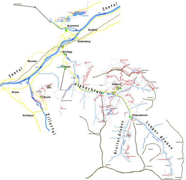
Here is a selection of walks in the Alpbachtal area of Alpbach, Tirol, Austria.
A good map to use is Mayr 428.
Click here for details of more walking / hiking maps in Alpbach and the surrounding area.

“Walking Easy in the Austrian Alps”
Chet & Carolee Lipton This US book covers day walks in Alpbach, Damüls, Kitzbühel, Neustift, Seefeld, Tschagguns - Schruns, Wagrain, Zell Am Ziller, Wien (Vienna). Walks are graded as ”Gentle”, “Comfortable”, and ”More Challenging”.There is also a chapter on getting to and about Austria, what to take, and information about Austria.
|
Amazon UK |
Amazon DE |
Amazon US |
Amazon CA |
© 2005-2025
A Fielding
All Rights Reserved
|
|
| Subscribe to Hiking Alps |
| Visit this group |
- Home
- Countries
- eurounion
- austria
- Alpbach
- Altmünster
- Bad Aussee
- Bad Ischl
- Bruck an der Großglocknerstrasse
- Ebensee
- Ellmau
- Fieberbrunn
- Filzmoos
- Fuschl
- Galtür
- Gmunden
- Hallstatt
- Igls
- Innsbruck
- Kaprun
- Kitzbühel
- Kufstein
- Mayrhofen
- Mittersill
- Mutters
- Niederau
- Oberau
- Obergurgl
- Pertisau
- Ramsau
- Rattenberg
- Reith im Alpbachtal
- Saalbach-Hinterglemm
- Salzburg
- Schladming
- Seefeld
- Söll
- St. Anton
- St. Gilgen
- St. Johann
- St. Wolfgang
- Strobl
- Telfes
- Traunkirchen
- Waidring
- Westendorf
- zellsee
- switzerland
- Before You Travel
- Holiday Paperwork
- Holiday Travel
- Accommodation
- Walking Clothes
- Walking Equipment
- Books & Maps
- mapinfo
- Kuemmerly Frey Maps
- Valser Maps
- Alpine Club maps
- mayr maps
- freytag berndt maps
- Kompass maps
- Kompass Paper Maps
- Kompass Digital Maps
- Kompass Map 4309
- Kompass Map 4290
- Kompass Map 4291
- Kompass Map 4292
- Kompass Map 4293
- Kompass Map 4294
- Kompass Map 4295
- Kompass Map 4296
- Kompass Map 4297
- Kompass Map 4001
- Kompass Map 4003
- Kompass Map 4004
- Kompass Map 4025
- Kompass Map 4026
- Kompass Map 4032
- Kompass Map 4043
- Kompass Map 4044
- Kompass Map 4052
- Kompass Map 4056
- Kompass Map 4066
- Kompass Map 4070
- Kompass Map 4102
- Kompass Map 4187
- Kompass Map 4191
- Kompass Map 4221
- Kompass Map 4230
- Kompass Map 4231
- Kompass Map 4232
- Kompass Map 4233
- Kompass Map 4234
- Kompass Map 4235
- Kompass Map 4237
- Kompass Map 4239
- Kompass Map 4240
- Kompass Map 4241
- Kompass Map 4242
- Kompass Map 4243
- Kompass Map 4250
- Kompass Map 4251
- Kompass Map 4331
- Kompass Map 4334
- Kompass Map 4371
- Kompass Map 4372
- Kompass Map 4650
- Kompass Map 4701
- Kompass Map 4705
- Kompass Map 4737
- Kompass Map 4750
- Kompass Map 4770
- Kompass Map 4804
- Kompass Map 4837
- Kompass Map 4850
- Kompass Map 4852
- Kompass Map 4853
- Kompass Map 4854
- Alpenwelt maps
- Resorts
- Walks, Hikes
- Alpine Fauna
- Alpine Flora
- Mountain Huts, Cafés
- Technology
- Privacy, cookies
