Mittersill, Salzburger Land, Austria

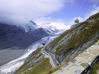
Großglocknerstraße road through the Hohe Tauern Nationalpark


Mittersill Location
Click here for a Region Map of Mittersill and details of walking / hiking maps.
Mittersill, Austria is about 24 km west of Zell am See, and 26 km south of Kitzbühel. To the north are the Kitzbüheler Alpen and to the south is the Hohe Tauern Nationalpark with the highest mountain in Austria, the Großglockner, and Italy.
Walking / Hiking in the Mittersill Area
There are over 1000 km of paths in the Hohe Tauern National Park south of Mittersill including the highest mountain in Austria. The area north west of Mittersill (Kitzbüheler Alpen) also has a number of lifts and walks in the Resterhöhe area.
Click here for walks in the Mittersill area.
The Tourist Office may offer free led walks.
Skiing in the Mittersill Area
The main skiing area is north of Hollersbach im Pinzgau, which is 5 km west of Mittersill. You can get there by bus to Hollersbach and then cable car, or by bus north to Pass Thurn.
Other skiing areas are at Zell am See and Kaprun. All year skiing is available at Kaprun on the Kitzsteinhorn.
Mittersill is part of the SkiWelt Wilder Kaiser-Brixental and the Kitzbüheler Alpen Ski Region so the skiing area covers a large area.
Kitzbüheler Alpen Ski Region comprises of:
- Skigebiet Kitzbühel (Kitzbühel, Kirchberg, Jochberg, Pass Thurn, Mittersill Oberpinzgau)
- SkiWelt Wilder Kaiser-Brixental, (Brixen im Thale, Ellmau, Going, Hopfgarten, Itter, Kelchsau, Scheffau, Söll, Westendorf)
- Skiregion Schneewinkel (St. Johann in Tirol, Oberndorf, Kirchdorf, Erpfendorf, Fieberbrunn, St. Ulrich, St. Jakob, Hochfilzen, Waidring, Reit im Winkl)
- Hochtal Wildschönau (Niederau, Oberau, Auffach, Thierbach)
- Skigebiet Alpbachtal (Alpbach, Reith, Kramsach).
Mittersill Hiking / Walking Maps
There are several maps that cover the area at different scales suitable for walking, hiking and exploring the area.
Click here for Mittersill Map Information.
Mittersill Tourist Information
Mittersill Plus GmbH
Marktplatz 1
5730 Mittersill
Austria
Tel. +43(0)6562 4292
Fax +43(0)6562 5007
Airports near to Mittersill (Flughafen)
The nearest airport to Mittersill is Salzburg.
- Innsbruck: 110 km - 2h 00 mins
- Salzburg: 100 km - 1h 45 mins
- Munich: 160 km - 2h 20 mins
Rail Stations (Bahnhof)
The Pinzgauer Lokalbahn (PLB) (Krimmlerbahn or PinzgauBahn) runs west from Zell am See along the Pingau valley via Mittersill to near the Krimml waterfalls. From here there is a bus connection to the waterfalls - you can get a combined ticket. There are a number of steam trains.
There is a train station in Zell am See - about 24 km from Mittersill. It is on the edge of Zell am See town next to the lake. From Zell am See the main line runs north to Saalfelden then west to Kitzbühel & Innsbruck, and south to Bischofshofen then north to Salzburg.
ÖBB (English) also has bus information.
Buses
There are a number of bus routes from Mittersill. West to Krimml and Mayrhofen; east to Zell am See; north to Kitzbühel.
ÖBB (English) also has train information.
Cable Cars - Chair Lifts
There are no cable cars or chair lifts in Mittersill. The nearest lift is in Hollersbach im Pinzgau, which is 5 km west of Mittersill.
There are also lifts in Kaprun and Zell am See.
© 2005-2025
A Fielding
All Rights Reserved
|
|
| Subscribe to Hiking Alps |
| Visit this group |
