|
Views around Filzmoos and Promenade (Herzerlweg) path |
|
|
Dr.-März-Weg to Roßbrand (Radstädter Hütte) (1770m) and back via Karalm. |
|
|
Filzmoos to Hofalm via Wallehenhütte then back to Filzmoos. |
|
|
Walk via Moosalm to Mandling. Return by Talweg and Stausee to Filzmoos. |
|
|
Kleinbergalm to Marcheggsattel and Kirchgasshütte then to Neuberg. Walk back to Filzmoos by path south of main road. |
|
|
Wanderbus to Marcheggsattel. Walk to Kirchgasshütte then to Hofpürglhütte. Return via Unterhofalm and Oberhofalm to Filzmoos. |
|
|
Car to near Rettensteinhütte. Walk via Wallehenhütte, Sulzenalm, Sulzenhals and Eiskarlschneid. Descend via Rinderfeld to Unterhofalm and Oberhofalm. Return to Filzmoos by Wanderbus. |
|
|
Wanderbus to Bachlalm. Walk via Maralm and Walcheralm to Brandalm. Return via Glösalm and road to Filzmoos. |
|
|
Walk via Weitenhausalm (Nössleralm) to Bachlalm. Return by Wanderbus to Filzmoos. |
|
|
Wanderbus to Oberhofalm. Walk to Sulzenalm and Sulzenhals and descend to Bachlalm. Return via Weitenhausalm (Nössleralm) to Filzmoos. |
|
|
Postbus to Radstadt. Walk via part of road to Roßbrand (Radstädter Hütte) and then by Steinalm and Stausee to Filzmoos. |
|
|
Wanderbus to Neubergerhof. Walk to Gsengplatte and Schäferhütte, then via track and path to Gsengalm and Lettenhof. Then walk back by road to Filzmoos. |
|
|
Wanderbus to Marcheggsattel then walk via Kirchgasshütte and Sulzkaralm to Hofpürglhütte. Then to Unterhofalm and Oberhofalm. Walk back to Filzmoos. |
|
|
Wanderbus to Bachlalm. Walk via Maralm to Tor. Descend to Sulzenhals and then to Bachlalm. Return by Wanderbus to Filzmoos. |

Click here for details of walking /hiking maps in Filzmoos and the surrounding area.
Bergwanderungen im Dachsteingebirge und in den Niederen Tauern. Auswahlführer für die Gebiete rund um Schladming und Radstadt: Radstadt - Filzmoos - Ramsau - Schladming - Sölk
Filzmoos Walks
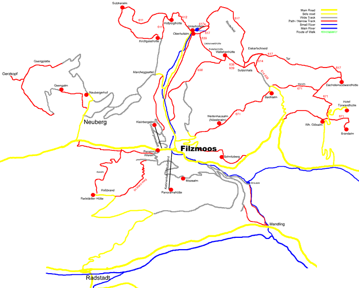
The walks around Filzmoos, Austria are varied. They are classified like ski pistes with Blue (easy), Red (medium) and Black (hard).
The map below shows only the paths and tracks of the walks. Chose a day from the links to see details and pictures of that day's walk. Map of all walks (bottom of this page)
© 2005-2025
A Fielding
All Rights Reserved
|
|
| Subscribe to Hiking Alps |
| Visit this group |
