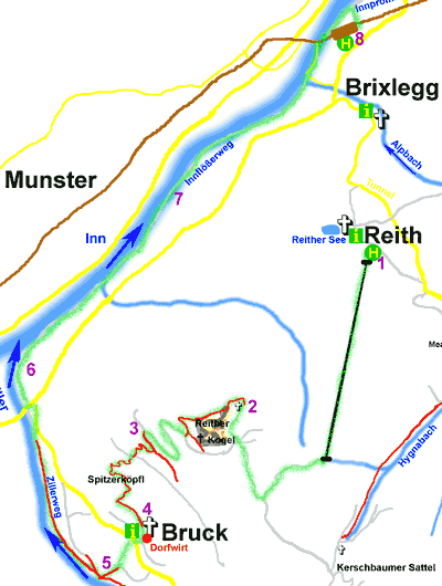
Directions: Take the bus to the Reith Lift [1], ascend to the top of the lift and take track R11 and then R29 to the east side of Reither Kogel. Pass the small kapelle [2] and go up path R29 to Reither Kogel. Take the path from the top descending steeply down the west side to a track (R29). Turn right and 400m after the 2nd hair-pin bend, turn left [3] and take a path across a meadow into woods. After 200m, turn left at a junction down to Spitzerköpfl and then into Bruck [4]. From the information office, head south west and take the path across the field down to the riverbank [5]. Turn right and follow the Ziller river north to join the Inn river [6]. Continue along this track (R7 Innflößerweg) [7] to Brixlegg. Return to Alpbach by bus [8].
Alpbach Walk 9 - Reith, Reither Kogel, Bruck, Brixlegg and Return
Refreshments: Dorfwirt
Description: This walk takes the Reith lift and then goes over the Reither Kogel and descends over Spitzerköpfl to Bruck. It then follows the rivers to Brixlegg.
Date reviewed: Spring 2005
|
Start: |
Reith |
|
End: |
Brixlegg |
|
Distance: |
km |
|
Reither Kogel Kapelle |
1.25 |
|
Reither Kogel |
0.38 |
|
Spitzerköpfl |
1.75 |
|
Bruck Dorfwirt |
0.87 |
|
Zillerweg |
0.62 |
|
Innflößerweg |
2.00 |
|
Brixlegg Bahnhof |
1.13 |
|
TOTAL |
8.00 |

© 2005-2025
A Fielding
All Rights Reserved
|
|
| Subscribe to Hiking Alps |
| Visit this group |
- Home
- Countries
- eurounion
- austria
- Alpbach
- Altmünster
- Bad Aussee
- Bad Ischl
- Bruck an der Großglocknerstrasse
- Ebensee
- Ellmau
- Fieberbrunn
- Filzmoos
- Fuschl
- Galtür
- Gmunden
- Hallstatt
- Igls
- Innsbruck
- Kaprun
- Kitzbühel
- Kufstein
- Mayrhofen
- Mittersill
- Mutters
- Niederau
- Oberau
- Obergurgl
- Pertisau
- Ramsau
- Rattenberg
- Reith im Alpbachtal
- Saalbach-Hinterglemm
- Salzburg
- Schladming
- Seefeld
- Söll
- St. Anton
- St. Gilgen
- St. Johann
- St. Wolfgang
- Strobl
- Telfes
- Traunkirchen
- Waidring
- Westendorf
- zellsee
- switzerland
- Before You Travel
- Holiday Paperwork
- Holiday Travel
- Accommodation
- Walking Clothes
- Walking Equipment
- Books & Maps
- mapinfo
- Kuemmerly Frey Maps
- Valser Maps
- Alpine Club maps
- mayr maps
- freytag berndt maps
- Kompass maps
- Kompass Paper Maps
- Kompass Digital Maps
- Kompass Map 4309
- Kompass Map 4290
- Kompass Map 4291
- Kompass Map 4292
- Kompass Map 4293
- Kompass Map 4294
- Kompass Map 4295
- Kompass Map 4296
- Kompass Map 4297
- Kompass Map 4001
- Kompass Map 4003
- Kompass Map 4004
- Kompass Map 4025
- Kompass Map 4026
- Kompass Map 4032
- Kompass Map 4043
- Kompass Map 4044
- Kompass Map 4052
- Kompass Map 4056
- Kompass Map 4066
- Kompass Map 4070
- Kompass Map 4102
- Kompass Map 4187
- Kompass Map 4191
- Kompass Map 4221
- Kompass Map 4230
- Kompass Map 4231
- Kompass Map 4232
- Kompass Map 4233
- Kompass Map 4234
- Kompass Map 4235
- Kompass Map 4237
- Kompass Map 4239
- Kompass Map 4240
- Kompass Map 4241
- Kompass Map 4242
- Kompass Map 4243
- Kompass Map 4250
- Kompass Map 4251
- Kompass Map 4331
- Kompass Map 4334
- Kompass Map 4371
- Kompass Map 4372
- Kompass Map 4650
- Kompass Map 4701
- Kompass Map 4705
- Kompass Map 4737
- Kompass Map 4750
- Kompass Map 4770
- Kompass Map 4804
- Kompass Map 4837
- Kompass Map 4850
- Kompass Map 4852
- Kompass Map 4853
- Kompass Map 4854
- Alpenwelt maps
- Resorts
- Walks, Hikes
- Alpine Fauna
- Alpine Flora
- Mountain Huts, Cafés
- Technology
- Privacy, cookies
